 |
 |
 |
|
|
|
The Short Walking Group
Leader: John Howlett - ShortWalk@ashbyu3a.co.uk - phone 01530 461774
The leader will be at the meeting place whatever the weather and only cancel the walk in consultation with those who turn up on the day. All dogs must be kept under control at all times. Walking boots or strong shoes are recommended. Be prepared for bad weather by taking warm WATERPROOF clothing. Leaders act in a voluntary capacity. All ramblers walk at their own risk. The walk will be about 2 or 3 miles and not include any stiles.
Future programme | ||||
| Date | Time | Venue | Leader | duration/distance |
Friday 15th May. Grace Dieu Wood
The day was bright, dry and breezy, with a slight chill to the air when nine walkers gathered in the carpark behind the Bulls Head pub.
Brian led us off out of the carpark and through the low arch under the old railway viaduct and rightwards into the woods. We strolled along in alternating sunshine and cloud parallel to the railway viaduct (now a walkers’ path) for a while as the viaduct grew lower and eventually sank below our path. Then Brian turned us away and downhill towards the brook at the bottom. With sunshine coming and going, the scent of wild garlic loud in the air, and the sunlight glinting off the water we paused for a group photo.
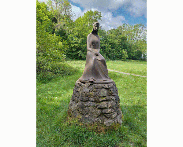
Unable to cross the raging torrent (!) we strolled along parallel to it and eventually, crossing the line of an old canal, out into the open fields to the west of the ruins of the Priory. After a visit to the serene statue of the Mother Superior, we returned to the canal and went round to the ruins themselves. These are worth a visit all by themselves, but we contented ourselves with wandering in and out among them trying to interpret all the various features.
We then returned via the path parallel to the viaduct to the car park. We walked around one and a quarter mile in very pleasant weather and beautiful surroundings. Naturally, coffee and cakes were required to round off the day, so we repaired to the ever-friendly Wellie Dellie.
For those curious about the railway and canal: the former (the Charnwood Forest branch of the L.N.W.R) ran from the car park of the modern Lidl store on the A6 in Loughborough due west to a point north of Grace Dieu, then curved around to go southwards past the Priory and on towards Thringstone, Whitwick, Coalville and points south.
The canal (much older than the railway) snaked around the countryside to the west from Thringstone up to Osgathorpe and back down to the Priory, then wanders away to the east and Nanpanton; much of its track still identifiable today in field boundaries.
Thank you Brian for an excellent morning’s outing.
Photos by John D. and John H.